
Destination: Westwood Inn from Bella Coola
(Added: 07.31.2012)
Click Map to Enlarge
Route Notes
- Suggested Altitude: Varies with Leg
- Landing zone is: Water or Land
- GPS for destination: N51 5.56 W125 36.95
- Distance approximately: 60 Miles
- Download PRINT-ABLE copy HERE
- Flight-Seeing Flight Plan & Map HERE
- Trip Ticket FAQ Usage HERE
- Scenery Needed: PFJ, PNW, Owikeno Lake and Westwood Inn, AI Boats for Westwood.

Click Image to Enlarge
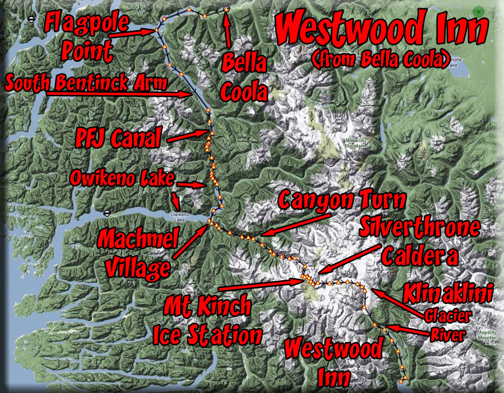
This flight takes you from Bella Coola Airport (CYBD) down over the Owikeno Lake area and up the Machmel River. You then turn off and head toward the Silverthorne Caldera glacier area. You will encounter Mt Kinch Ice Station then down the Klinanklini Glacier to the Klinaklini River where you will find the Westwood Inn at the river's outfall.
WaveTop/TreeTop Flight Plan
FROM: Bella Coola BC (CYBD)
TO: Westwood Inn
Leg: Bella Coola to Pacific Fjords Gateway Airstrip
Initial Course: 235
Leg Distance: 36 Miles
Leg Altitude: 1200 Feet
Start at Bella Coola and fly on a heading of 235 over the town of Bella Coola and past the marina out over Bachelor Bay. Follow the bay to the first point of land, Flagpole Point to port and round that point turning into the South Bentinck Arm on a rough heading of 136. Stay to the starboard shore for courtesy, planes taking off from the airstrip ahead will fly their starboard side shore. Fly this heading for about 22 miles, it ends at the Pacific Fjords Gateway Canal area. Over the airport, begin following the canal that will first turn sharply to port, later sharply to starboard, then again to port following a river down to Brad's BBQ on the north shore of Lake Owikeno.
Leg: Pacific Fjords Gateway Airstrip to Brad's BBQ North
Initial Course: Follow the Canal (about 200*)
Leg Distance: 9 Miles
Leg Altitude: 1200 Feet
Over the PFG Airstrip, turn to port and follow the canal. It will soon turn sharply to port. Follow the canal to the river, then turn to port to follow the river to the north shore of Owikeno Lake and Brad's BBQ there. You can land if you like and look around.
-
On this leg, watch for the scenery below, there are lodges, cabins, boats, waterfalls on both sides, and of course the canal itself.
Leg: Brad's BBQ North to Machmel Village
Initial Course: 174
Leg Distance: 12 miles
Leg Altitude: 1200 Feet
As you fly over Brad's BBQ, look to the right and you will see the waterfalls at Keet's Creek. You then fly to the "3rd Narrows" ahead, a narrow part of the lake and again out over a widened lake. Watch for boat traffic below on this leg. You will see a second narrow area (2nd Narrows), then you will see the Owikeno Airstrip North and a small farm nearby. Follow the lake as it turns to starboard . You will see another narrows come up to starboard ahead. Owikeno South Airstrip is ahead and Machmel Village is just beyond that. At the Village, you will be turning to port flying up the Machmel River
-
As you come over Owikeno North Airstrip (and the farm) look back to port and you will see the Sheemahant River .
Leg: Machmel Village to Canyon Turn
Initial Course: 100
Leg Distance: 10 Miles
Leg Altitude: 2500 Feet
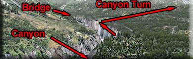
We turn up the Machmel River on a rough heading of 100 and follow the river. In about 5 miles, you will notice the river forming a sharp-sided canyon. Watch carefully for a branch off to starboard ... that is Canyon Turn. There is a cabin at the outfall of the tributary there. Begin increasing altitude to 2500 feet.
-
Notice the river is "river-scaped' ... there are marker buoys all the way up this river to the Monastery some 30 miles ahead. You can drive a boat the length of this river.
Leg: Canyon Turn to Glacier Turn
Initial Course: 102 (follow the canyon)
Leg Distance: 9 Miles
Leg Altitude: 4400 Feet
Follow the canyon. Continue increasing your altitude to 4400 feet. You will pass over a glacial lake with a curving glacier ahead. That is "Glacier Turn" and you will curve to starboard following the glacier.
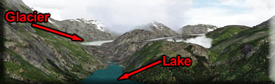
Leg: Glacier Turn to Mt Kinch Ice Station
Initial Course: 069 (follow glacier to starboard)
Leg Distance: 5 Miles
Leg Altitude: 7500 feet (Climb steeply!)
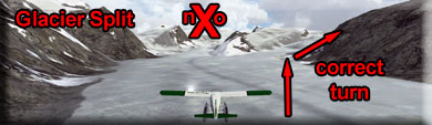
The Glacier curves to starboard, follow the glacier climbing to 7500 feet. The glacier splits ... straight ahead and off to starboard. Take the starboard turn, continuing to climb steeply. .
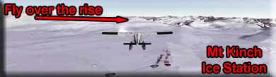
Leg: Mt Kinch Ice Station to Klinaklini River
Initial Course: 075
Leg Distance: 15 Miles
Leg Altitude: Descend to 1200 feet (descend with glacier)
As you fly over the ice station, you will see a slight "rise" on the horizon ahead about 2 miles. Fly over that rise. The rise is 8200 feet (the highest point of this trip). When you cross over it, you will see a glacier ahead.
Once you fly over the rise. You will see a glacier ahead and to port. Turn to a heading of 075, fly to that glacier and follow the glacier as it curves to starboard. (There is a split to port, do not go to port, continue to starboard).
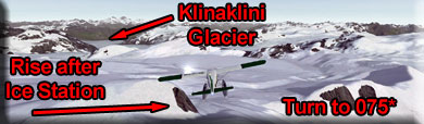
You may descend down to about 1200 feet above the glacier and continue descending with it to the Klinaklini River where the glacier ends and the river begins.
Leg: Klinaklini River to the Westwood Inn
Initial Course: 136
Leg Distance: 15 Miles
Leg Altitude: 1200 feet above the terrain, descending.
You are now entering the beautiful Klinaklini River basin. Follow the slow curves of the river. The river goes all the way to Knight Inlet. The Westwood Inn is at the outfall of this river. You will find it to starboard. From this direction, fly low over the Inn and get your bearings on this very trick and small runway. Then circle out over the inlet and come back and land. The GPS flight plan will take you over the site.
Welcome to the Westwood Inn.